Overview

What is a Floodplain?

A floodplain is an area of land that is prone to flooding and is susceptible to being flooded by flood waters of any source. It is important to protect our natural floodplains, as they can steer development away from sensitive natural areas and protect Florida's mangroves. 

Natural floodplains provide flood storage, filter stormwater runoff and improve water quality, provide habitats for various fish and wildlife (including endangered species). Do what you can to help keep our streams and creeks free of debris. 

Flood Zones Defined

What is a Flood Zone?
Flood zones are geographic areas that FEMA has defined according to varying levels of flood risk. These zones are depicted on a community's Flood Insurance Rate Map (FIRM), and reflect the severity or type of flooding in the area. Flood Insurance Rate Maps (FIRMs), are used to determine flood insurance premium rates and some building code requirements. Special Flood Hazard Areas (SFHA) are defined as the area that will be inundated by a flood event having a 1-percent chance of being equaled or exceeded in any given year.

What is a Special Flood Hazard Area?
Flood hazard areas identified on the Flood Insurance Rate Map are identified as a Special Flood Hazard Area (SFHA). The most common flood zones in Martin County are: A, AE, AH, AO, VE, X and X (shaded). Every structure is in a flood zone, but not all flood zones are Special Flood Hazard Areas. Zones A, AE, AH, AO, and VE are all considered to be Special Flood Hazard Areas.

“100-year Flood” Misconception: 
People sometimes hear the phrase “100-year” flood and think a flood happens only once in one hundred years. That old adage is not true. The Special Flood Hazard Area is an area that has a 1 percent chance, or a 1 in 100 chance, of a flood happening in any given year. That means a flood could happen this year and again the next year. It has nothing to do with calendar years. The phrase “1 percent annual chance of flood” is more accurate.

X Zone:
The X zone (also known as “low–risk flood zone”) is an area outside of the Special Flood Hazard Area. It’s important to know that just because an area is designated as X zone does not mean that the area will never flood.

Remember!

Everyone lives in a flood zone — it's just a question of whether you live in a low, moderate, or high-risk area.

FEMA Flood Zones Map

Find Your Flood Zone

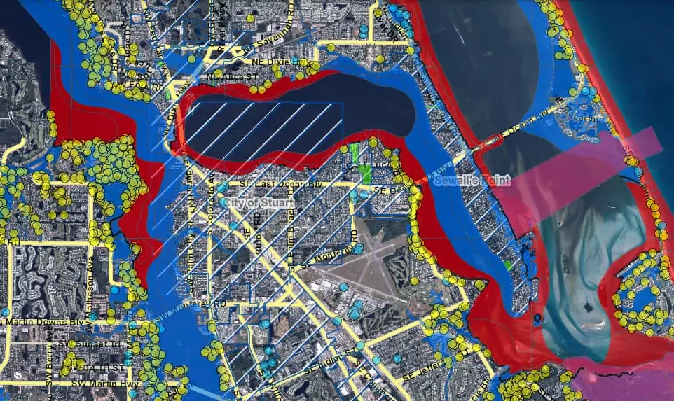
To determine your home's flood zone, access Martin County's FEMA Flood Zones Map. Once the map is open, enter your address in the search bar or use the navigation tools to locate your property.

FLOOD ZONE DESIGNATIONS

Special Flood Hazard Areas:

  • High-risk zones
  • Begin with “A” or “V”
  • Flood insurance required

These areas face the highest risk of flooding. If you own a property in a high-risk zone and have a federally backed mortgage, you are required to purchase flood insurance as a condition of that loan.

Non-Special Flood Hazard Areas:

  • Moderate- to low-risk zones
  • Begin with “X”, “B” or “C”
  • Flood insurance recommended

In these areas, the risk of being flooded is reduced, but not completely removed. One in three insurance claims come from moderate- to low-risk flood areas.

Source: Floodsmart.gov — Understanding My Flood Zone

what's the difference?

Flood zones are NOT the same as evacuation zones, though they are often mistaken for each other. Flood zones and evacuation zones have different purposes and measure different conditions that may not occur at the same time. A home may be located in a non-evacuation zone, yet still be located in a high-risk flood zone because of a nearby stream or pond.

Flood Zones Evacuation Zones
Used to determine flood insurance rates Used to determine extent of coastal storm surge

Geographic areas that FEMA has defined according to varying levels of flood risk. Various sources of flooding include, but are not limited to: riverine, poor drainage, sheet flow, coastal, storms, etc.

Flood Zone maps (which are officially called Flood Insurance Rate Maps or FIRMs), are used to determine flood insurance premium rates and some building code requirements.

By law, flood insurance is required for federally backed mortgaged homes residing in flood zones beginning with the letters A or V. These zones are known as the Special Flood Hazard Area (SFHA).

These zones are determined by the National Hurricane Center and indicate areas that may be inundated by an abnormal rise of water pushed onto shore by a hurricane or storm event. Storm surge zone maps are used to determine evacuations.

Storm surge evacuation zones are different from flood zones. Evacuation zones are used only in emergencies to move away from a dangerous storm. When a storm/hurricane is approaching, it’s time to know your evacuation zone.

Evacuation zones in Martin County are identified as AB, CD and E, and some areas of the county are not located in any evacuation zone.

Find Your Flood Zone Find Your Evacuation Zone

Flood Insurance

Most homeowner’s insurance policies usually do not cover damage from floods. However, because Martin County participates in the National Flood Insurance Program (NFIP), you can purchase a separate flood insurance policy backed by the Federal government.

What is the National Flood Insurance Program?

The National Flood Insurance Program (NFIP), which is administered by the Federal Emergency Management Agency (FEMA), is a federal provider of flood insurance policies. Martin County participates in the NFIP, which enables residents to obtain flood insurance through the program. Through the NFIP, the county adopts FEMA Flood Insurance Rate Maps (FIRMs), which determine the cost of flood insurance and set construction standards in various flood zones.

Community Rating System

Under the National Flood Insurance Program (NFIP), Martin County also participates in a voluntary program called the Community Rating System (CRS). Joining the CRS enables communities to earn premium reductions for their residents for floodplain management activities that a community implements.

In CRS communities, flood insurance premium rates are discounted to reflect the reduced flood risk resulting from the community's efforts that address the three goals of the program:

  • Reduce and avoid flood damage to insurable property
  • Strengthen and support the insurance aspects of the National Flood Insurance Program
  • Foster comprehensive floodplain management

MARTIN COUNTY CRS RATING:

As of 2023, Martin County has improved its rating within the CRS to a Class 5, which provides unincorporated Martin County residents in a Special Flood Hazard Area (SFHA) a 25% premium reduction, and a 10% premium reduction for those in a non-SFHA. When you renew your flood insurance policy, please check for your "Community Rating Number" stated on your policy.

Learn more: Discounts on Flood Insurance Premiums for CRS Communities

Flood insurance is required for homes with a federally-backed mortgage that are located in a Special Flood Hazard Area (SFHA), although all property owners are encouraged to obtain flood insurance – regardless of their designated flood zone.

All zones can flood for a variety of reasons. There have been multiple instances of homeowners in low to moderate risk flood zones (Flood Zone X) who have experienced significant flooding.

The typical homeowner’s insurance policy does not include coverage for damage resulting from flooding, even if hurricane winds and rain caused the flood to occur. If you own a home in Martin County, please discuss the need to purchase separate flood insurance coverage with your insurance agent and visit the Flood Smart website for more information.

Building in the Floodplain

Notice to property owners: Did you know that almost all permitted development within unincorporated Martin County requires a floodplain review? The following are general guidelines for building in a Special Flood Hazard Area (SFHA).

Overview

It is important to build responsibly and safely.  Any new structure or improvement to a structure, whether it is an addition, alteration, re-roof, etc. must have a building permit prior to the start of construction.

All applications to build in a Special Flood Hazard Area (SFHA) will not only include building department review but also a floodplain review performed by the Floodplain Coordinator, Floodplain Administrator or designee. This review is to ensure compliance with FEMA regulations, Martin County's Flood Protection Ordinance, Martin County's Building and Housing Regulations and Florida Building Code Requirements

During this process, if an improvement to the structure is deemed to be substantial, it is then required that the applicant demonstrate the structure meets the current Florida Building Code requirements, County codes, and FEMA standards and regulations. These regulations are in place to protect both people and buildings.

It is required that the lowest finished floor of any new or substantially improved structure located within a Special Flood Hazard Area be a minimum of 1-foot above the Base Flood Elevation (BFE), which is found on the Flood Insurance Rate Map.

This also applies to attached garages, enclosures, crawlspaces, and any machinery servicing the building. Parking, storage, and building access areas that are not habitable spaces may be located below the BFE, only if flood openings are present or the structure is floodproofed (non-residential only). 

While structures located within a V Zone are also required to be built a minimum of 1-foot above the BFE, they must also be protected from the impact of waves, hurricane force winds, and erosion.

A V Zone Design Certificate must be prepared by a professional engineer or architect that certifies that the design and planned methods of construction meet NFIP requirements. This certificate is required prior to permit issuance.

Floodproofing is acceptable for non-residential buildings in Special Flood Hazard Areas; however, there are certain requirements to be compliant with regulations that also include a Floodproofing Certificate. For more information, contact the Floodplain Coordinator.

All new or substantially improved structures will require a finished construction Elevation Certificate which must demonstrate compliance.  This will be required prior to receiving a Certificate of Occupancy or Certificate of Completion.

Always get a permit before you build and work with a State of Florida licensed contractor.

Martin County participates in the Community Rating System (CRS) established by FEMA through the National Flood Insurance Program. This requires the county to determine if improvements over the past five-year period are substantial, meaning the cumulative value of the improvements meets or exceeds 50% of the value of the structure being improved.

This requirement applies only to structures that are within a Special Flood Hazard Area (SFHA) and are not compliant with current Flood Protection regulations. It does not matter whether the structure is residential or commercial, insured or uninsured, nor first-floor or top-floor condominium.

If a structure located in a SFHA is not built to the current design flood elevation, and is "substantially damaged" or "substantially improved," it must be brought into compliance with the Martin County Floodplain Management Ordinance and Florida Building Code, including elevating the building and all electrical and mechanical equipment to a minimum of 1-foot above the base flood elevation.

This typically applies to the addition to or remodeling of older structures, but it also affects structures that have sustained major damage.

Overview

All new construction and substantial improvements to a structure built in a Special Flood Hazard Area (SFHA) are required to have a finished construction Elevation Certificate.

The certificate is used to demonstrate compliance with the requirements of the National Flood Insurance Program (NFIP) and is required to obtain flood insurance, which is mandatory for all structures in the SFHA.

Please note any new or substantially improved structure located within a Special Flood Hazard Area requires the lowest finished floor be a minimum of 1-foot above the Base Flood Elevation (BFE). This also applies to attached garages, enclosures, crawlspaces, and any machinery servicing the building.

Martin County Public Works Department and the Building Department may also require any other floodplain-related documents and construction certificates that are appropriate for the structure, e.g., a Floodproofing Certificate, V-Zone Certificate, and/or Certification of Engineered Flood Openings, etc.

The construction certificates must be prepared by a Florida licensed surveyor, professional engineer, or certified architect. The original should then be submitted to Martin County Public Works, where it will be reviewed, scanned and recorded. Digitally signed elevation certificates will not be accepted.

Where can I find my Elevation Certificate?

Martin County has most Elevation Certificates on record for homes built after 1991 located within a Special Flood Hazard Area (SFHA). You can download a copy of your Elevation Certificate from Martin County's FEMA Flood Zones Map.

How to download: To find your elevation certificate, launch the FEMA Flood Zones Map, then in the map, search for your address or parcel ID. If there is an Elevation Certificate on file, it will be indicated by a yellow dot on the parcel with a link to download the Elevation Certificate. If you cannot find the elevation certificate you are looking for, you may also Submit a Request.

The Federal Emergency Management Agency (FEMA) issued an updated Flood Insurance Study and associated digital Flood Insurance Rate Maps that were adopted by Martin County Board of County Commissioners and became effective on March 16, 2015.  This study included analyses for rivers, streams, and creeks but did not include a coastal flood risk analysis.

In 2011, FEMA initiated a coastal flood risk study for east coast and central Florida. The study focused on the areas that affect Brevard, Indian River, Martin, and St. Lucie Counties.  The study included an analysis of storm surge, wave hazards through modeling, and mapping.

The results were incorporated into an updated Flood Insurance Study (FIS) and digital Flood Insurance Rate Maps for these counties. The 5 volumes of the FIS report can be read via the links below.

FEMA combined its coastal risk study with its current flood maps, which became effective on February 19, 2020.

  • Know your hazard. Inland flooding is a leading weather-related cause of death in the United States. 
  • Identify the flood zone for your neighborhood and surrounding businesses.
  • Know the difference between a flood watch and a flood warning: 
    • Flood watch = Conditions are favorable for flooding
    • Flood warning = Flooding imminent or occurring
  • Make sure you have an emergency plan and a disaster supply kit ready in the event you and your family need to evacuate. Always remember: "Turn Around Don't Drown"!

Download Flood Safety Tips Fact Sheet

Contact Us

If you have any additional questions about flood protection information in Martin County, please select the "Contact Us" button below to submit an online inquiry, or contact the Martin County Floodplain Coordinator at (772) 288-5466.